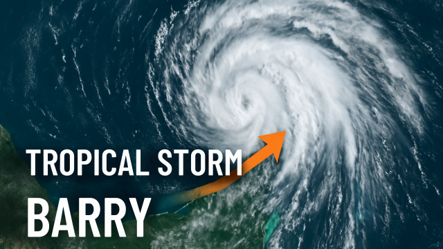
Tropical Storm Barry might not have made headlines for devastating winds, but the way it evolved from a disorganized swirl into a tropical system with real consequences made it one of the most dynamic weather events of early summer 2025. The changes were fast, subtle at first, and then critical—shifting track, intensifying just enough, and bringing heavy rain and rough surf to Mexico’s east coast. Tropical Storm Barry was a textbook example of why early-season Gulf storms demand close attention, even when they don’t look dramatic on the surface.
It all started in the Bay of Campeche in late June, where sea surface temperatures hovered around 84°F. That’s about 1°C warmer than average for the season, and warm water like that can act like rocket fuel for tropical systems. At first, this low-pressure area didn’t seem like much. Satellite imagery showed a scattered cluster of thunderstorms, poorly organized, with no clear center. But beneath that mess, atmospheric conditions began aligning. Flight-level reconnaissance by the Air Force Reserve Hurricane Hunters found wind speeds of 51 knots at the 850-millibar level, enough to support an upgrade. On June 29 at 18 UTC, the National Hurricane Center officially named it: Tropical Storm Barry was born.
What changed so quickly? A lot. First, Barry’s intensity jumped. From a tropical depression with uncertain structure, it was suddenly clocking 40-knot sustained winds—about 45 mph at the surface. This was confirmed not only by aircraft but also by satellite-based tools like SATCON and ADT, which both indicated Barry was holding that strength. This marked the first significant shift: Barry was no longer a vague system, it was a real storm, and it was headed toward land.
Then came the change in speed and direction. Earlier models had suggested a more sluggish drift, but Barry picked up momentum, moving northwest at nearly 8 knots. That adjustment nudged its projected landfall point slightly east, closer to Cabo Rojo and not far from Tampico. This shift aligned well with updated ECMWF model data and showed just how responsive Barry was to upper-atmosphere steering. While the storm didn’t grow rapidly, its track pivoted in a way that required fast adaptation from forecasters and emergency response teams.
Structurally, Barry also transformed. While moderate wind shear—about 20–25 knots—continued to tug at the storm, pushing its central convection southeast, radar imagery out of Tampico began picking up a more coherent core. That’s when the system stopped looking like just a wet mess and started resembling a true tropical cyclone. Convection began organizing into curved bands, particularly on the northeastern quadrant. This is a familiar pattern in sheared tropical storms: the low-level center stays exposed while convection flares on one side. But in Barry’s case, it was enough to maintain tropical storm strength and drive significant rainfall onto the Mexican coast.
Environmental factors played a big role here too. The warm waters of the Bay of Campeche gave Barry a deep well of moisture, helping it overcome some of the vertical wind shear that would normally tear a storm apart. Still, the shear did its job in one way—it prevented Barry from organizing further. This is why, despite warm seas and solid inflow, the storm never intensified beyond 45 mph. For Mexico, that was a small blessing, but the rainfall still packed a punch.
Heavy rain began falling along the coast, particularly in Veracruz and southern Tamaulipas. Forecast models from the Weather Prediction Center indicated 3 to 6 inches of rain with local totals near 10 inches. That’s more than enough to trigger flash flooding, especially in the mountainous areas just inland. Rivers like the Pánuco and Cazones began swelling, and authorities in Tampico and Tuxpan activated emergency shelters. Some highways, including portions of Federal Highway 180, experienced closures due to mudslides and tree fall.
The most remarkable part? Barry went from unnamed blob to named storm with landfall in less than 48 hours. That compressed timeline put pressure on everyone—forecasters, emergency services, and coastal residents alike. It also highlights a bigger issue with Gulf storms: there isn’t always time for days of preparation. Barry was a reminder that rapid organization is common in this region, and warm oceans make it even more likely in the years to come.
As Tropical Storm Barry moved inland late on June 30, its winds dropped off quickly. The storm lost its tropical structure within 12 to 18 hours of landfall, as expected. But by then, the rain had already done its work. Flash flooding was reported across multiple zones, particularly in narrow valleys where runoff collects fast. While the system didn’t bring catastrophic impacts, it did enough to disrupt transportation, threaten small communities, and complicate the start of the week across eastern Mexico.
Looking at Barry’s short but eventful life, it’s clear the storm delivered more than expected for its category. It didn’t roar, but it soaked. It didn’t break records, but it forced real-time action. In a season that had barely begun, Barry served as a reminder that intensity is only part of the tropical equation. Speed of formation, rainfall potential, and storm motion matter just as much—sometimes more.
In the big picture, Barry also played into a broader climate signal. Warmer Gulf waters, faster formation times, and harder-to-predict steering flows are all becoming more common. Tropical Storm Barry ticked all those boxes. It may not be the biggest name on the list this year, but it gave us a preview of what the rest of the season might hold. As we head deeper into 2025, the Gulf Coast, Mexico, and the southeastern U.S. should keep their eyes open. Because if Barry taught us anything, it’s that the next tropical storm doesn’t need to be a hurricane to cause real trouble.