When Tropical Storm Barry swirled to life in the Bay of Campeche at the tail end of June 2025, it didn’t come roaring in like a lion. It didn’t need to. Barry was the quiet type, a storm that doesn’t get hyped for wind speed but instead earns respect for what it leaves behind. It spun up quickly, made landfall just as fast, and soaked parts of Mexico in rain totals that felt more like a tropical monsoon than a passing system. Tropical Storm Barry might not have made headlines worldwide, but for those in its path, it was a sharp reminder that water, not wind, is often the biggest threat.
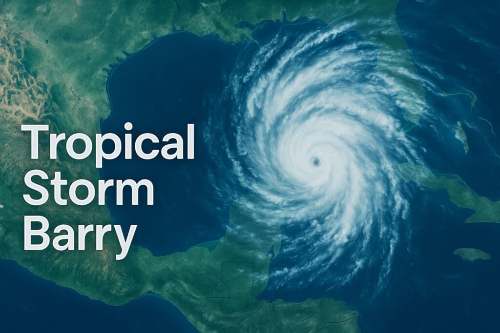
Barry became the second named storm of the Atlantic season after Tropical Storm Andrea. It was born from a sprawling low-pressure area in the southern Gulf of Mexico, the kind of moist, chaotic mess that often lurks over the Bay of Campeche during summer’s early weeks. In this case, Barry didn’t linger. Warm sea surface temperatures in the high 80s, combined with just enough organization aloft, gave Barry the energy it needed to strengthen. By June 29, 2025, the system reached tropical storm status with winds of 40 mph and a projected landfall just north of Veracruz.
At first glance, a 40 mph tropical storm might not seem like much. No hurricane-force winds, no towering eyewalls, no swirling drone footage. But that’s where Barry’s real lesson comes in. The storm delivered heavy rains, localized flash flooding, and dangerous surf, even though it never intensified past a modest tropical storm. This wasn’t a dramatic rapid intensification event, but it was a well-timed reminder of how vulnerable Gulf communities remain, especially early in the season.
What made Tropical Storm Barry unique wasn’t just its speed, it was the specific ingredients it brought together. The western Gulf was hot—about 1 °C warmer than average for this time of year. That heat gave Barry a moisture-rich environment to tap into. On top of that, the system had a tight core with persistent convection, despite moderate wind shear. Barry didn’t need to grow much to become a problem. It only had to drift north-northwest toward Mexico’s densely populated coastal plain, and that’s exactly what it did.
Cities like Tampico, Tuxpan, and Nautla were directly in Barry’s path. Though official wind readings stayed below 45 mph, gusty squalls brought down trees and damaged roofs. Highway 180, a key transport route along the coast, saw road blockages from landslides and flooding. Power outages were reported in several rural areas, especially where fragile grid infrastructure couldn’t handle the surge in wind and rain. Meanwhile, further north, the Texas coastline watched with unease. South Padre Island and Corpus Christi didn’t experience direct impacts, but Barry’s surf field reached across the Gulf, stirring up rip currents and heightened wave action.
Tropical Storm Barry made landfall late on Sunday night, June 29, just north of the city of Nautla. It quickly weakened as it moved inland, but the rain didn’t stop. Totals of 4 to 8 inches fell across the Sierra Madre foothills, with isolated pockets receiving as much as 10 inches. Those numbers might seem small compared to major hurricanes, but in steep terrain with limited drainage infrastructure, that kind of rainfall is dangerous. Rivers like the Pánuco and Cazones swelled rapidly, and low-lying neighborhoods in Tampico experienced flooding within hours. Authorities opened temporary shelters in schools and municipal buildings, helping keep residents out of harm’s way.
Mexico’s civil protection agencies were quick to act. By the time Barry made landfall, more than twenty emergency shelters had been set up along the coast. Evacuation plans were ready, and in some regions, preemptive measures like sandbag walls helped slow the pace of incoming floodwaters. It wasn’t a flawless response, but it was a good one. Most of the public messaging emphasized rain, not wind, and that likely saved lives. In this case, the biggest risk wasn’t falling trees or flying debris—it was water rising too fast to outrun.
If there’s one consistent thread across modern storms, it’s this: don’t underestimate rainfall. Time after time, storms like Barry make landfall with low wind speeds, only to wreak havoc through flash floods and landslides. Meteorologists have said it for years, but public perception is hard to shift. When people hear “tropical storm,” they often relax. No Cat 1, no boarding up windows, no panic shopping. But Barry shows that even a weak storm on paper can be destructive in real life.
The scientific community is also watching storms like Barry closely. Warmer sea surface temperatures in the Gulf are becoming more common, and that shifts the balance. It doesn’t take a Category 3 storm anymore to trigger widespread flooding. As the climate continues to warm, tropical storms could bring more frequent extreme rainfall events, even if wind speeds remain low. That’s a big deal for early-season storms like Barry, which form close to land and leave little time for communities to prepare.
For storm trackers and forecasters, Barry’s rapid formation was a reminder that Gulf systems don’t always give much warning. The storm was born and named within 36 hours. Forecast models handled it fairly well, but that narrow window between detection and landfall left little room for error. It also left less time for public outreach, especially in rural areas where information doesn’t spread quickly.
Looking back, Tropical Storm Barry won’t go down as one of the great storms of our time. It didn’t tear roofs off buildings or cause billion-dollar damage. But for the people it did touch, it was memorable. It was a wake-up call, not a knockout punch. The storm made clear that every system, no matter how “small” it seems, carries weight. In a world where warmer oceans are fueling more frequent and unpredictable storms, that’s not something anyone can afford to ignore.
Barry may be gone, but the Gulf is heating up. The season is young, and other names are waiting their turn. If Barry is any indication, 2025 could be another year where the unexpected becomes the norm. Whether you live in Mexico, Texas, or anywhere along the Atlantic basin, now is the time to check your flood plans, review your emergency kit, and remember that tropical storms like Barry are more than just windy days—they’re reminders that water wins more battles than wind ever will.