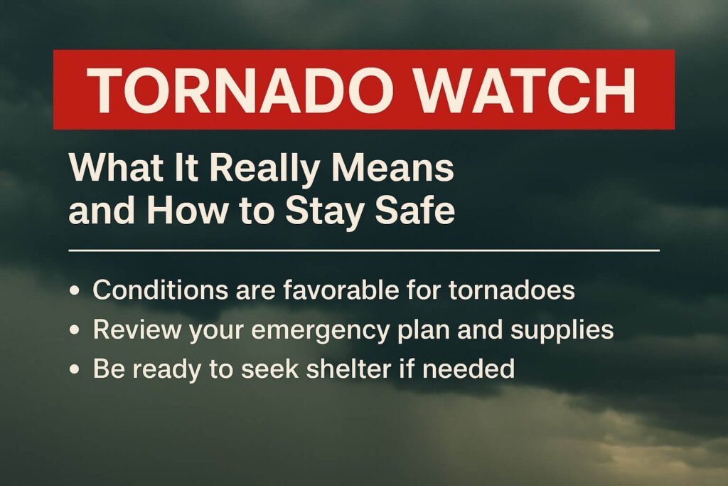
When the sky darkens and your weather app lights up with a tornado watch, it can spark a mix of confusion and worry. The words themselves sound alarming, yet they don’t mean a tornado has been spotted. A tornado watch is a heads-up from the National Weather Service that conditions are favorable for tornadoes to develop. It’s not a guarantee that one will touch down, but it’s your signal to pay attention, make a plan, and stay ready.
Across the southern United States, from Louisiana to Mississippi and Alabama, these watches are common during spring and fall storm seasons. The most recent tornado watch for the Capital Region near Baton Rouge highlighted this clearly. It was issued overnight as warm air, unstable winds, and a strong cold front came together. Meteorologists described it as a “favorable environment for rotating storms.” For many residents, it was a reminder that a tornado watch is a period of preparation, not panic.
What a Tornado Watch Means
A tornado watch means the atmosphere has all the ingredients needed to form severe thunderstorms capable of producing tornadoes. Warm, moist air rises into colder layers above, and wind direction changes with height. This creates a twisting motion in the sky that can lead to rotating thunderstorms known as supercells. When these supercells mature, they can drop tornadoes with little warning.
Watches are issued by the Storm Prediction Center, a branch of the National Weather Service that monitors severe weather nationwide. When their experts see a pattern coming together, they issue a watch that covers several counties or parishes for up to six hours. Local offices then share that alert, and TV meteorologists spread the message to help everyone prepare.
It’s important to know that a watch is not the same as a warning. A warning means a tornado has been spotted on radar or confirmed by trained storm spotters. That’s when you move to your safe place immediately. A watch means you have time to review your plan, secure outdoor items, and make sure you have multiple ways to receive alerts.
A good way to remember it is simple. A watch means be ready. A warning means take shelter now.
What To Do During a Tornado Watch
When a tornado watch is issued, don’t ignore it or assume it’s routine. Use it as your cue to get prepared. Start by reviewing your shelter options. The safest place in your home is an interior room on the lowest floor with no windows. Bathrooms, closets, or hallways work well. If you live in a mobile home or temporary structure, identify a sturdier nearby shelter and plan how to get there quickly.
Keep your phone fully charged and your notifications on. If you have a NOAA Weather Radio, make sure it’s set to your local frequency. These radios are designed to wake you up if a warning is issued while you’re sleeping. That’s especially important for overnight watches like the one that just affected the Baton Rouge area. Tornadoes at night are more dangerous because they’re hard to see and people are often asleep.
Gather a small emergency kit with a flashlight, water, shoes, and a helmet if you have one. Many injuries during tornadoes happen from flying debris. A helmet and sturdy shoes can make a big difference.
Check the radar regularly, but don’t get glued to your screen. Trust official updates from the National Weather Service, your local TV meteorologists, or CycloneRadar’s real-time severe weather page. Avoid relying solely on social media posts, as misinformation can spread quickly during active weather.
If the watch escalates to a warning for your area, don’t wait to see the storm. Move to your shelter immediately and stay there until the all-clear is given.
Why Tornado Watches Are So Important
Some people overlook tornado watches because many pass without major damage. But the purpose of a watch is not to predict every tornado that will happen. It’s to highlight a time window when the atmosphere is primed for severe storms. Meteorologists call this “situational awareness.” By knowing you’re in a watch area, you can act faster when a warning is issued later.
Behind every watch, there’s a team of meteorologists studying radar loops, temperature maps, wind shear data, and satellite imagery. When they issue a tornado watch, it means the science says the potential is there. Whether or not a tornado forms depends on many small factors, but the watch buys you crucial time to prepare.
The overnight watch in the Capital Region is a good example. It lasted from late evening through dawn and covered multiple parishes. Some areas only saw heavy rain and gusty winds, while others had rotating storms on radar. The watch served its purpose. It gave residents time to stay alert and ready for any warnings that followed.
In severe weather, readiness saves lives. Tornadoes can form in just minutes. Once a warning is issued, you may only have a few moments to act. That’s why a tornado watch matters. It’s the calm before the storm when small decisions make the biggest difference later.
Stay connected to official sources, trust the alerts you receive, and know your plan before the sky turns dark. Whether you’re in Louisiana, Oklahoma, or Tennessee, that simple awareness can keep you and your family safe when severe weather threatens.