The Caribbean has witnessed countless tempests, but Hurricane Melissa is shaping up to be one of those storms people will remember for decades. Right now, all eyes are fixed on the hurricane melissa path, a twisting, unpredictable trail that has evolved from a sluggish tropical system into a roaring Category 4 powerhouse.
It started quietly, almost deceptively, south of Hispaniola. Melissa churned over warm waters, drawing energy slowly at first. Satellite images showed a broad, messy swirl, but it was clear something serious was brewing. As days passed, the system began to tighten its core, pulling in heat and moisture from the Caribbean Sea. Jamaica and southern Haiti were drenched with endless rain, as if the storm was testing its own strength. Then came the rapid intensification that meteorologists always dread to see. Within just a short window, Melissa exploded into a full-blown Category 4 hurricane, with winds roaring near 150 miles per hour.
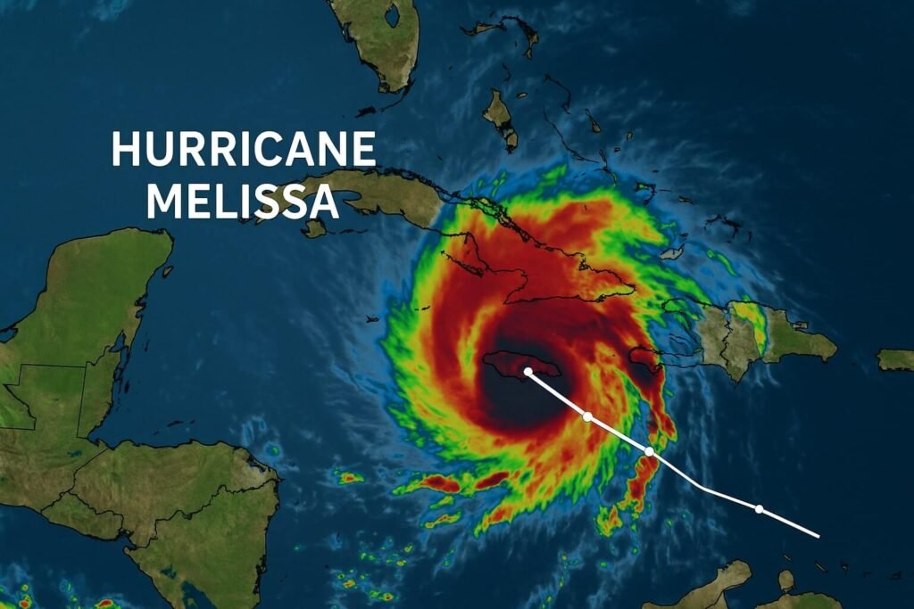
By Sunday morning, the National Hurricane Center confirmed that Melissa had reached major hurricane status. Pressure dropped sharply, and the eye of the storm became almost perfect on satellite imagery. It was a sign of a storm that had found its rhythm. The forecast cone placed the center of Hurricane Melissa dangerously close to Jamaica, showing only a small margin between a near miss and a direct hit. The air was heavy across the island, not just with humidity, but with the tense awareness of what was coming.
Jamaica, Cuba, and Beyond: Understanding the Path Ahead
The hurricane melissa path now traces a slow drift toward the west before curving north and then northeast. This curve is not random. Meteorologists explain that a trough—a kind of low-pressure corridor—developing over the southeastern United States is steering the hurricane away from Central America and toward the open Atlantic. Before that turn happens, though, Jamaica will face the full force of Melissa’s outer eyewall. That means destructive winds, massive storm surges, and rainfall totals that can trigger deadly landslides in mountainous terrain.
Forecast models agree on the general direction, though the exact track wobbles slightly from one update to the next. The storm is expected to move very slowly near Jamaica on Monday, making landfall or passing dangerously close by Tuesday morning. Afterward, it will likely cross the southeastern edge of Cuba by late Tuesday or early Wednesday, then head toward the southeastern Bahamas and the Turks and Caicos Islands. The slow pace near Jamaica is the part that worries forecasters most, since slow-moving hurricanes dump far more rain than fast ones. When the storm sits over one spot, rivers rise, slopes collapse, and the sea surges farther inland than expected.
By the middle of the week, Hurricane Melissa will start picking up speed as it gets caught in stronger steering currents. The NHC expects it to lose some strength after brushing Cuba, though it will likely remain a strong hurricane as it moves over the warm waters near the Bahamas. Beyond that, long-range models suggest it could pass close to Bermuda by Friday, bringing high surf and strong winds even if it stays offshore. The hurricane melissa path at that stage looks more predictable, but every mile matters when you’re talking about a storm this large.
What Makes Hurricane Melissa So Dangerous
It’s not only the wind that makes Melissa a threat. The real danger lies in how slowly it moves. Rainbands have already been battering parts of Hispaniola and Jamaica for days, and as the core arrives, rainfall rates could exceed 10 to 15 inches in some areas. That much water falling in a short time turns streets into rivers and hillsides into avalanches of mud. Even coastal regions that escape a direct hit could see destructive surf and dangerous rip currents.
Another factor that complicates the hurricane melissa path is its potential for eyewall replacement cycles. These are natural phases where the inner eye collapses and a new one forms, temporarily weakening the storm but spreading the wind field outward. That means even areas outside the immediate path might still experience hurricane-force gusts. The National Hurricane Center has warned that fluctuations in strength will continue, but the bottom line remains unchanged: Melissa is an extremely dangerous storm for Jamaica, southeastern Cuba, and the Bahamas.
If you live anywhere in those regions, you don’t need to focus on the exact track line. What matters is that this storm is large, powerful, and slow-moving. Prepare for prolonged high winds, widespread flooding, and long power outages. Coastal surge warnings are already in effect for southern Jamaica, where waves are expected to rise several meters above normal tide levels.
Melissa will eventually curve northeast into the Atlantic, but its impact will linger long after its center has moved away. Communities will face cleanup, power restoration, and the painful process of rebuilding. Even once it passes, the ocean it leaves behind will be dangerous for days, with large swells and strong rip currents affecting the Caribbean, Florida’s east coast, and Bermuda.