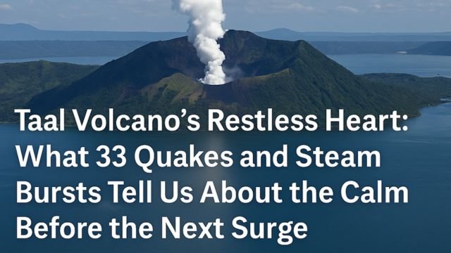
The Taal Volcano has always been one of those places that looks peaceful from a distance, like a postcard view from the ridgelines of Tagaytay. But if you look closer, especially over the last few days, that calm is deceiving. This compact yet incredibly complex system has been whispering its usual warnings again, this time with a series of volcanic earthquakes, short but sudden steam-and-ash eruptions, and a visible pulse in volcanic gas emissions.
On October 26, PHIVOLCS recorded three separate eruption events at the main crater of Taal. The first one began just after 6 in the morning, followed by two more later that morning. These weren’t the kind of eruptions that coat cities in ash or require wide evacuations, but they were very real. The plumes reached between one and two kilometers high, drifting southwest with the prevailing winds. Steam and volcanic gas hissed upward, with hints of ash in the second and third events. PHIVOLCS logged 33 volcanic earthquakes that day, each one a subtle reminder that magma is moving beneath the surface and interacting with water-saturated rock.
This is exactly the kind of behavior we’ve come to expect from Taal Volcano: small but meaningful signs, building into a pattern that might shift at any moment.
Why Taal Volcano behaves this way
Taal is not a mountain in the traditional sense. It’s a volcanic system built inside a caldera, which itself sits inside a large freshwater lake. Volcano Island, the area where most activity is centered, lies within this lake. And within that island is the main crater, which holds its own lake. That’s water sitting right on top of volcanic heat, a recipe for quick reactions.
When magma rises and releases heat and gas, it pushes against this water-rich environment. Sometimes that pressure escapes gently through vents, creating plumes of white steam. But when gas builds up faster than it can escape, and when water flashes to steam suddenly, it can result in what’s called a phreatomagmatic eruption. That’s what likely caused the brief but dramatic events last week.
Even when Taal Volcano is quiet, the system underneath is never still. Groundwater moves through hot fractured rock, gases like sulfur dioxide bubble upward, and pressure builds in sealed pockets. The trick is that this volcano can flip its behavior quickly. One moment it’s calm, with just a bit of steam. The next moment, there’s a burst of ash and gas, caught on webcams and posted on social media within minutes.
The number of volcanic earthquakes is one of the clearest indicators of unrest. Thirty-three in a day might sound small, but they’re enough to show that pressure is shifting and fluids are moving underground. Combine that with sulfur dioxide emissions (which were at 436 tonnes on October 25) and visible upwelling in the crater lake, and you get a clearer picture: the volcano is degassing, reacting, and keeping its shallow hydrothermal system active.
What the alert level really means right now
PHIVOLCS has kept Taal Volcano at Alert Level 1. That doesn’t mean there’s nothing happening. It means that there is low-level unrest, and while a large eruption isn’t imminent, the area around the main crater remains dangerous. Entry onto Volcano Island is strictly prohibited, and that includes boating near the main crater and doing fish cage work close to it. Gas can accumulate in pockets above the water, and sudden eruptions could put anyone nearby at risk.
The permanent danger zone around the crater exists for a reason. The 2020 eruption, which sent ash all the way to Metro Manila, showed how quickly things can escalate. Since then, Taal has had periodic pulses, with short-lived phreatomagmatic events in 2021 and 2022. These events didn’t reach the same scale, but they revealed the same pattern: short warning time, water-magma interaction, and immediate danger for those near the crater.
When the alert level stays at 1 but quakes, gas, and steam activity rise, it’s a signal to stay alert without panic. It’s not about fear, it’s about readiness.
If you’re near the lake, especially in towns like Laurel, Agoncillo, or Talisay, you’ve probably grown up with Taal always in the background. The volcano’s activity isn’t new, but the tools we have to understand it have gotten better. Look at the official bulletins, especially the daily updates from PHIVOLCS. They include SO₂ levels, quake counts, plume height, and wind direction. All of that helps locals make better decisions. If a plume is drifting toward your town, it’s smart to keep windows closed and minimize outdoor activity.
For those curious from afar, the story of Taal Volcano is not about dramatic explosions every week. It’s about reading the rhythm, watching the gas, and understanding that the line between quiet and active is very thin in a system like this.
So what happens next?
If the current pattern continues, with minor quakes and occasional steam bursts, we might see more of the same: short eruptions, increased plume activity, and frequent alerts about gas buildup. If gas emission levels rise into the thousands of tonnes, or if quakes grow more intense, PHIVOLCS may raise the alert level.
For now, the recommendation remains simple. Respect the danger zone. Watch the daily bulletins. Don’t go onto the island. If you’re visiting Tagaytay for the views, enjoy them from the ridge, not the crater.
Taal is one of the most studied volcanoes in the world because of its location and history. But no amount of data changes the reality that it can erupt suddenly. It’s a volcano with a temper, shaped by water, pressure, and heat.
It doesn’t take a towering mountain to cause trouble. Sometimes, a lake hiding a restless heart is enough.