Monsoon rains are supposed to bring life to the high desert, not flip entire houses into rivers. Yet on 8 July the sleepy mountain village of Ruidoso watched its little Rio Ruidoso leap more than six metres in under an hour. In the video clips locals shared in real time, you can hear the disbelief before the roar of the water swallows every other sound. That sudden wall of mud did not stop in Lincoln County. By dawn the next day fresh flash-flood warnings stretched from the pecan groves near Carlsbad all the way up to the ponderosa slopes around Las Vegas, New Mexico. New Mexico flooding made headlines everywhere, and for good reason: it was dramatic, fast and frightening, but also a wake-up call about how burn scars and a warming atmosphere team up to turn ordinary storms into dangerous torrents.
What Happened on the Ground
The story begins with a ridge of high pressure wobbling west of El Paso. That subtle shift opened a highway of subtropical moisture straight up the Rio Grande corridor. Forecasters in Albuquerque flagged the setup days ahead, yet even they were surprised by how fiercely it unfolded near Ruidoso. Short-wave troughs rode the moisture plume, popped towering cumulonimbus clouds over the Sacramento Mountains, then wrung out sixty to seventy millimetres of water in barely ninety minutes over slopes stripped bare by last year’s South Fork and Salt wildfires. New Mexico flooding was suddenly not a forecast idea, it was banging on doors.
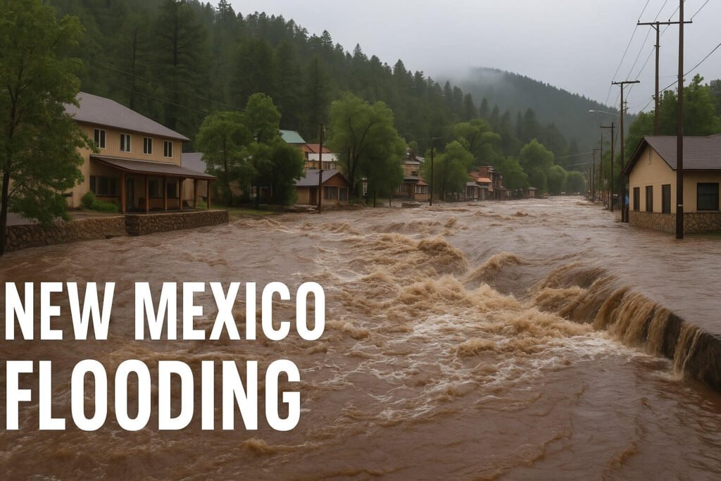
Residents who thought they had a normal rain shower stepped outside to find the street curbs already running like brown rapids. At 3:35 p.m. the first Flash Flood Warning hit phone screens. Ten minutes later the wording escalated to a Flash Flood Emergency. In that twenty-minute window, the Hollywood stream gauge on the Rio Ruidoso climbed from a gentle 0.55 metres to an unbelievable 6.17 metres. That crest shattered an old record that had stood since 1963. By four o’clock cars, picnic tables and one two-storey frame house were tumbling down-canyon. More than eighty swift-water rescues followed before night hid the chaos.
The new mexico flooding headlines kept rolling northward. Intense thunderstorms pounded the Hermit’s Peak burn scar above Las Vegas just as locals tried to finish dinner. Debris-filled water raced down steep arroyos, undercut stretches of NM-518, and forced impromptu ditch inspections at acequia associations before morning light. Meanwhile farther south, rural firefighters stationed sandbag pallets at Eddy and Chaves county stations, because every arroyo feeding Dark Canyon can flash in minutes once monsoon air turns unstable.
Simple numbers paint the picture:
- Peak three-hour rainfall in Upper Gavilan Canyon: 68 mm
- Rio Ruidoso crest at Hollywood: 20.24 feet, well into major-flood stage
- Road closures statewide at flood peak: 32 individual segments
- Flash-flood polygons issued between 5 and 9 July: 47 across four forecast zones
None of those statistics capture the human edge. Families scrambled to move pets upstairs, shop owners hauled sandbags with bare hands, and one retired couple escaped their log cabin seconds before a propane tank ripped free and went bobbing down Main Street. A few folks admitted they nearly stayed put because they “had never seen the creek angry before.” That honest hesitation cost them vehicles and furniture, though mercifully not their lives.
Why Burn Scars Matter, and What Comes Next
If you hike Ruidoso’s forest trails today you notice an unsettling contrast. Charcoal soil lies where a carpet of pine needles once soaked up rain like a sponge. Tree roots that used to lock hillsides together now dangle, exposed. After a wildfire, the waxy coating that heat bakes into the topsoil turns otherwise permeable ground into almost a parking lot. When it rains hard, water slides off instead of sinking in. New Mexico flooding is therefore a fire story as much as a weather one, and that will stay true for years. Thousands of hectares across the state bear similar scars, from the massive Calf Canyon burn in the north to smaller torch-offs scattered through the Manzano range. All create fast-runoff zones that feed creeks already primed by climate-charged moisture.
Scientists tracking monsoon behaviour say average precipitable-water values in early July 2025 beat the remnants of Hurricane Odile from 2014. Warmer air simply holds more vapour. Add wider burn scars and you have a double trigger. That mix turned Tuesday’s routine afternoon thunderhead into a conveyor belt of super-efficient rainfall. The lesson is blunt: expect more days like this, not fewer.
So what can residents and travellers do while skies still shimmer with thundercloud promise?
- Check the hourly forecast, not just the day summary. A sunny morning hides the fact that dew points are flirting with nineteen degrees Celsius at altitude, signalling juice for explosive storms.
- Never park or camp on a dry wash floor. Step eight vertical feet above any channel. That margin seems silly until it is the difference between wet shoes and a submerged SUV.
- Turn Around, Don’t Drown. Even forty centimetres of fast water can nudge a family sedan sideways. The new mexico flooding event showed that a one-metre surge will pick up a two-tonne pickup as if it were a toy boat.
- Stage sandbags in advance if you live below a scar. Moving them during a warning wastes precious seconds.
- Enable Wireless Emergency Alerts. Some people silenced them last season. They switched them back on after Tuesday’s scare. A ping is annoying until that ping is the only thing giving you five extra minutes.
Emergency managers have now raised the State EOC to Level 2. New Mexico National Guard high-water trucks stand ready. FEMA damage-assessment teams canvass Lincoln, Otero, Mora and San Miguel counties. Yet the greatest resource remains neighbour checking on neighbour. Folks in Ruidoso tell how a teenager with a drone mapped flooding side streets for first responders when cell service faltered. Another pair of volunteers, both sixty-something retirees, guided three nervous tourists uphill by flashlight because they knew a shortcut around a clogged bridge.
Forecast models keep precipitable water above thirty-five millimetres statewide for at least forty-eight more hours. That means any afternoon thunderstorm can again drop a quick half-inch that remobilises ash and logs. People are tired, some are discouraged, yet monsoon season still sits at the front end of its climatological curve. The good news is that awareness is also climbing. Tuesday’s drama replayed on local news loops, social feeds and dinner-table stories. The phrase new mexico flooding is no longer abstract, it is a lived memory, and memories push preparedness further than any pamphlet.
Final Thoughts
CycloneRadar exists to simplify big-weather talk for everyday readers. New Mexico flooding may look like a niche regional hazard, but its ingredients—burn scars, saturated air, steep terrain, show up all over the American West. If you travel, hike, or own property in similar zones, watch this event closely. Ask yourself, How quickly could water rise where I live? then act before clouds build. The next storm may not give a second warning.
Stay safe, stay curious, and keep an eye on those desert skies. Engines may roar louder than thunder down a canyon, but water, once set loose, moves faster than any truck can reverse. Knowledge shared, plans rehearsed and a healthy respect for flash flooding will keep more stories ending with relief rather than loss.