Every year, people scramble at the last minute—shoving clothes into duffel bags, topping up their tanks, and texting family members where to meet. The hurricanes don’t wait, and sadly, many folks find out too late that their homes sit inside a mandatory Hurricane Evacuation Zone. It’s the kind of detail you think you’ll check when a storm forms, but in reality? That moment comes fast. So today, let’s break it down: what a hurricane evacuation zone is, how to check yours, and why it’s more important than ever.
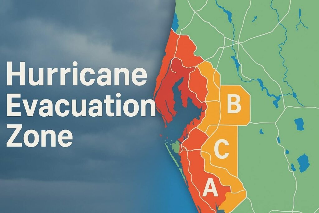
What Is a Hurricane Evacuation Zone?
Think of it as a risk map for storm surge. Not wind. Not rain. But the rising, rushing ocean water that can pour inland during a hurricane. Emergency managers use these zones to plan who needs to leave and when—based on how likely it is that those neighborhoods will flood.
Zones are usually labelled with letters (like A, B, C) or numbers (like Zone 1, 2, 3), with Zone A or 1 being closest to the coast and first to be evacuated. These maps are created using detailed models from NOAA and local engineers. They’re not about fear—they’re about flow.
If you evacuate early, roads stay clear. Shelters can prep. Families can move together. It’s not about panicking—it’s about planning. Knowing your hurricane evacuation zone means you’ll never be caught off guard.
Why the Hurricane Evacuation Zone Lookup Matters
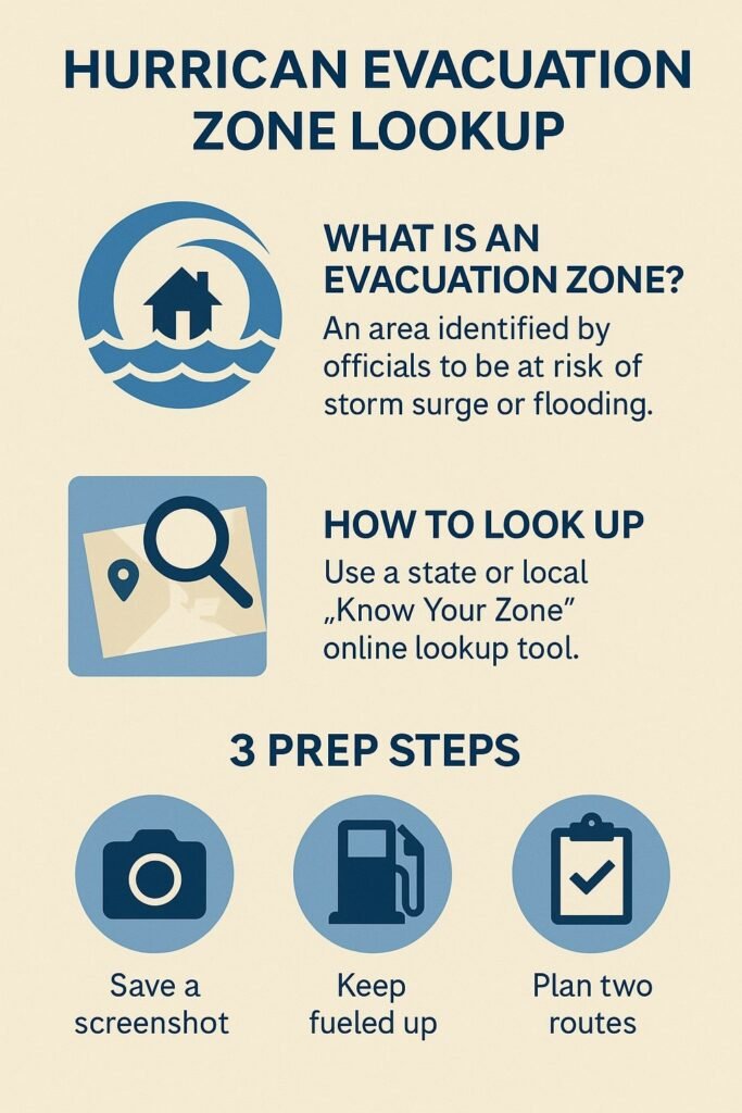
Because not all threats are visible. You can’t tell just by looking at your backyard if your house sits in a surge-prone area. Some zones stretch miles inland along rivers, creeks, or low-lying areas. That’s why the Hurricane Evacuation Zone lookup tools exist.
These official portals let you type in your address and instantly find your zone. That’s it. No guesswork. You’ll know if you’re in an area likely to get an evacuation order, and you can prep accordingly.
Checking your zone now means:
- You’ll know what to do when officials issue alerts.
- You can plan multiple exit routes.
- You’ll have time to make calm decisions instead of rushing.
When it comes to personal safety during hurricane season, understanding your hurricane evacuation zone is a non-negotiable first step.
Where to Check Your Zone (with Real Links)
Depending on your state, the tool might have a different name, but here are the most reliable ones:
- Florida: FloridaDisaster.org/knowyourzone
- Texas: DriveTexas.org
- Virginia: KnowYourZoneVA.org
- New York City: NYC Hurricane Zone Finder
- Louisiana: GetAGamePlan.org
- South Carolina: SCEMD Hurricane Guide
Many counties also offer ArcGIS-based hurricane evacuation zone maps that let you see your home in relation to other evacuation areas. Bookmark yours. Share it with your neighbors. Make it part of your seasonal routine.
How Zones Are Made: A Peek Behind the Scenes
Zone boundaries aren’t random—they’re crafted using something called the SLOSH model (Sea, Lake and Overland Surges from Hurricanes). The National Hurricane Center uses this tool to simulate thousands of storm scenarios and measure potential surge depths.
Then, local officials add in clearance times (how long it would take people to evacuate), road capacities, and shelter access. This layered approach helps cities and counties make smart calls—not blanket orders.
You don’t want everyone on the road at once. Zone-based evacuations solve that.
Don’t Confuse This With Flood Zones
Important: Hurricane Evacuation Zones are not the same as FEMA flood zones. Your property might not require flood insurance, but you could still be asked to leave during a hurricane.
Flood zones are based on annual chance of flooding and tied to insurance. Evacuation zones are about storm surge safety and tied to emergency planning.
So even if you’re outside a FEMA floodplain, don’t assume you’re safe. Use the official Hurricane Evacuation Zone lookup anyway.
3 Simple Steps to Prep Today
- Check your hurricane evacuation zone now. Don’t wait until a storm’s in the news. It only takes 30 seconds.
- Print or screenshot it. Cell towers go down during hurricanes. Keep a copy in your emergency folder.
- Plan where you’d go if asked to evacuate. It doesn’t have to be far—just somewhere safe and outside your zone.
The Role of Technology
Tools like HURREVAC (used by emergency officials) and ArcGIS zone overlays help power everything from push alerts to live maps during a crisis. Developers can even tap into open-source zone data to create hyperlocal dashboards.
Some states are testing AI-powered surge predictions to make evacuation calls even faster and smarter. But none of that matters unless you check your zone. Use your local hurricane evacuation zone map to stay one step ahead.
Know Before It Blows
Don’t wait until the cone is pointed at your city. Don’t rely on memory, assumptions, or your neighbors. The official Hurricane Evacuation Zone tools exist for a reason—use them.
Knowledge is the first step to resilience. Let this be the year you prepare not with panic, but with power. Make the hurricane evacuation zone lookup part of your seasonal checklist—it could save your life.