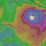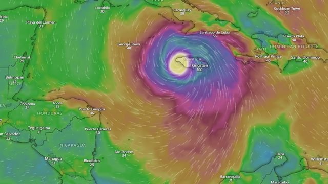
When hurricane Melissa charged into Jamaica on Tuesday, it wasn’t just another name in the long list of storms. It arrived as a monster, a once-in-a-generation Category 5 hurricane with sustained winds clocking at 185 mph. From early morning satellite loops to frantic emergency alerts, this was a storm that didn’t just flirt with danger, it redefined it. Hurricane Melissa struck the southwestern coast of Jamaica with unprecedented force, bringing with it destructive winds, terrifying storm surge, and a cascade of flooding rains that overwhelmed infrastructure and reshaped entire communities.
This is not just a story about wind speed or satellite images. It’s a story about people, panic, preparation, and the raw power of nature. When the eye of the hurricane passed over the Black River and New Hope areas, residents saw what few ever have: the stillness inside chaos, the eerie calm of the eye, then the punishing return of the eyewall. For Jamaicans, hurricane Melissa is now a name that will be etched into memory.
Let’s break down why this storm was historic, how it got so strong, and what it means for the region.
Jamaica’s Strongest Landfall on Record
Hurricane Melissa wasn’t just intense, it was record-breaking. The storm’s central pressure was recorded near 892 millibars by Hurricane Hunter aircraft, which places it among the lowest ever observed in Atlantic history. Only the 1935 Labor Day hurricane and Hurricane Wilma in 2005 reached similar extremes. Paired with its 185 mph sustained winds, Melissa became the strongest hurricane to ever make landfall in Jamaica.
This kind of intensity wasn’t just a meteorological oddity, it was the result of a perfect combination. Warm Caribbean waters, low vertical wind shear, and favorable upper-level conditions all collided to fuel a textbook case of rapid intensification. Melissa grew stronger by the hour as it neared land, surpassing forecaster expectations and leaving little time for the island to fully prepare.
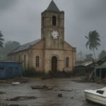
The eyewall swept across the southern and western parts of the island, including the parishes of St. Elizabeth, Westmoreland, and Manchester. Kingston, though not directly in the path of the eye, still experienced violent gusts, flooded roads, and widespread power loss. Government shelters filled quickly. Emergency responders worked through the night. Patients were moved to upper floors in hospitals to avoid the surge. Roads vanished under water. Hills gave way under relentless rain. In many ways, it was Jamaica’s darkest storm hour in living memory.
A Monster on the Move
Now that hurricane Melissa has passed over Jamaica, it isn’t done. The system remains a dangerous hurricane and is tracking toward southeastern Cuba, expected to reach the island late Tuesday into Wednesday. Heavy rain, flash floods, and hurricane-force winds are in the forecast for Cuba’s eastern provinces. From there, Melissa is expected to continue its arc toward the southeastern Bahamas, with hurricane watches already being issued across the Turks and Caicos and surrounding islands.
While no U.S. landfall is currently projected, coastal regions across Florida and the Southeast are bracing for indirect impacts. Dangerous surf, high rip currents, and strong outer bands could affect areas along the Atlantic coast in the coming days. It is a clear reminder that a hurricane doesn’t need to make landfall to cause trouble.
The Human Impact Behind the Numbers
It’s easy to get lost in the stats. 892 millibars. 185 mph winds. 13-foot storm surge. But behind those numbers are homes flattened, families separated, and entire towns without power or clean water. As of Tuesday evening, officials had confirmed several deaths in Jamaica and neighboring islands. Thousands were without shelter. Roads were impassable. Communication lines in some rural areas were down, making rescue and recovery efforts more difficult.
Power restoration could take weeks in some areas. Food distribution and medical aid are already being coordinated with international relief agencies. While global attention often shifts quickly after landfall, for residents, the storm is just beginning. The cleanup, the rebuilding, the grief, all of that lingers.
This storm was personal. For many, it brought flashbacks of Hurricane Gilbert in 1988, which was previously the most powerful hurricane to strike Jamaica. But Melissa was even stronger. The satellite images showed a perfect buzz saw. The sound of windows bursting and roofs ripping in the middle of the night is not something you forget. Nor is the smell of saltwater flooding into your living room.
Jamaica’s people are known for resilience. But resilience doesn’t mean untouched. It means rebuilding, even when broken. And this time, the island has been broken deeply.
What Comes Next
As hurricane Melissa churns northward, the Caribbean braces for more. Cuba and the Bahamas are next in line. Officials are urging anyone in the projected path to finalize preparations now. Don’t wait for the last minute. Listen to local weather authorities. Heed evacuation orders. Stay updated through the National Hurricane Center and local news channels.
Meanwhile, in Jamaica, the focus shifts to damage assessment, emergency aid, and slow but steady recovery. Roads must be cleared. Shelters need supplies. Families need to reconnect. And amid it all, the region holds its breath for what Melissa might still bring to others.
There will be time later to analyze the climate signals, the water temperatures, and the models. But for now, we sit with the reality that this storm was a worst-case scenario for an island too familiar with the sea’s fury.
Whether you’re in the Caribbean, the U.S. coast, or watching from afar, keep your eyes on hurricane Melissa. It is not done yet.