Hurricane Melissa, a name that will be remembered across the Caribbean for years, made a devastating landfall in Jamaica today, Tuesday, October 28, 2025. This isn’t just another major storm. It is one of the strongest hurricanes on record to strike the island, arriving with Category 5 winds, torrential rain, and a storm surge that threatens to completely transform parts of the coastline. For people in Jamaica and for anyone watching from nearby islands or afar, this post explains what has happened, why it’s so dangerous, and what might come next. Whether you’re checking on loved ones or preparing for the storm’s potential future path, this is your CycloneRadar-style breakdown of Hurricane Melissa.
A record-breaking landfall in Jamaica
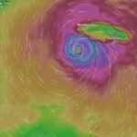
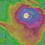
Hurricane Melissa intensified with astonishing speed before reaching Jamaica’s southern coast early Tuesday. Forecasters had been tracking the system as it rapidly developed from a Category 2 to a powerful Category 5 storm within just 36 hours. By the time Melissa’s eyewall reached land, it was packing sustained winds near 185 miles per hour, with gusts even stronger. For perspective, that’s in the same intensity range as Hurricane Dorian in 2019 and Hurricane Irma in 2017.
But what makes Melissa especially dangerous is its slow forward movement. Instead of tearing through quickly, it crawled across the island, subjecting parishes like St. Elizabeth, Manchester, Clarendon, and St. Ann to hours of destructive wind and relentless rain. The longer a storm lingers, the more damage it can cause. Roofs are peeled off, trees become airborne missiles, and power lines collapse. Local meteorological offices and The Weather Channel both confirmed that the storm’s center was moving at less than 10 miles per hour for much of Tuesday morning.
Rainfall totals are already staggering, with preliminary reports of 10 to 14 inches across central Jamaica and localized flooding in areas like Mandeville and May Pen. Mountain regions are experiencing even more, with runoff turning rivers into raging torrents. The Office of Disaster Preparedness and Emergency Management (ODPEM) warned residents in flood-prone zones to evacuate well ahead of landfall, but not everyone was able to leave. As a result, hundreds of shelters across the island are now filled, with many communities already reporting damage to homes, businesses, and vital infrastructure.
Storm surge is another brutal aspect of Hurricane Melissa. Coastal areas on the southern and southwestern edge, such as Black River and parts of Treasure Beach, are facing sea water levels rising 10 to 13 feet above normal. That’s enough to inundate single-story homes, sweep away cars, and completely submerge docks and harbors. Emergency teams have also raised concerns about erosion, particularly in areas where seawalls have already been compromised in past storms.
Why Melissa intensified so fast
Hurricane Melissa didn’t just grow stronger by chance. Conditions in the western Caribbean were practically perfect for rapid intensification. Sea surface temperatures remained unusually high for late October, hovering around 30 degrees Celsius. Warm water fuels hurricanes. When there’s little wind shear and a pocket of moist, unstable air, that heat gets converted into raw power.
Melissa found those exact conditions. Satellite images on Sunday already showed a tightly wrapped core, and by Monday morning, the eye had become well defined, surrounded by a symmetrical ring of deep convection. Once that eye stabilized, the storm deepened rapidly. Reports from the National Hurricane Center noted a pressure drop to around 892 millibars, making Melissa one of the most intense hurricanes by pressure in Atlantic history. That low pressure helped increase wind speed and created an especially compact but violent storm center.
Climate factors also played a role. Warmer oceans globally, combined with favorable atmospheric patterns, have led to more frequent rapid intensification events in recent hurricane seasons. Experts have flagged this trend over the last decade, and Melissa is yet another example of how storms are evolving. It’s not just about how big they are anymore, it’s how quickly they get there.
What to expect next, in Jamaica and beyond
Even as Hurricane Melissa begins to exit Jamaica, the danger is far from over. Power outages have already spread across the island. Internet and mobile networks are unstable or offline in many regions. In several cases, emergency services can’t even access neighborhoods cut off by fallen trees or flash flooding.
In the short term, rainfall will continue through Tuesday evening into Wednesday morning, especially in elevated areas. Landslides are a growing concern, particularly in eastern parishes like Portland and St. Thomas. If you’re in a hillside community, keep watch for cracks in the earth or sudden shifts in trees and soil.
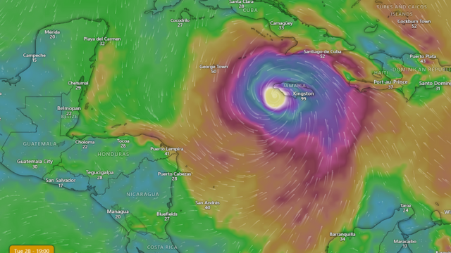
After Jamaica, Hurricane Melissa is forecast to move toward southeastern Cuba by late Tuesday night or early Wednesday. While some weakening is expected due to the interaction with Jamaica’s mountainous terrain, Melissa will likely still be a Category 3 or stronger as it approaches Cuba. The Bahamas should be watching closely as well. The broader wind field is expanding, meaning even if the core isn’t as strong, the reach of damaging winds and rainfall is growing.
Weather agencies across the Caribbean are urging continued vigilance. A small shift in the forecast track could put more islands in the danger zone. While Melissa may lose some intensity, the storm remains a serious threat because of its size, forward speed, and overall structure.
If you live in southeastern Cuba or the Bahamas, here’s what you should do today:
- Monitor official advisories from your local weather service and the National Hurricane Center.
- Secure loose outdoor items. A storm doesn’t need to be Category 5 to turn patio chairs into projectiles.
- Fill your water containers and fully charge all power banks and mobile devices.
- Stay informed with radios or battery-powered news sources in case of blackouts.
The world is watching how Jamaica weathers this storm. The images and videos emerging from the island already show widespread damage. Entire communities have been torn apart in a matter of hours. The recovery will take time, resources, and support from both local agencies and international aid.
For now, the priority is survival and safety. Once Melissa passes, the true scale of devastation will become clearer. But one thing is certain, this storm will be a defining event in Jamaica’s modern climate history. It will likely be compared to Hurricane Gilbert from 1988, if not surpassed in sheer strength and impact. As the storm moves on, its name will become shorthand for resilience, hardship, and the raw power of nature.
CycloneRadar will continue tracking Hurricane Melissa as it moves northward. Whether you’re in Jamaica, Cuba, the Bahamas, or anywhere in the wider Caribbean, stay safe, stay alert, and remember: hurricanes don’t need to last long to change everything.