Hurricane Melissa Jamaica is now a phrase you’ll be hearing a lot more of. What started as a tropical storm quickly exploded into one of the most powerful hurricanes ever recorded near the island. Right now, Jamaica is bracing for a direct and devastating blow as Melissa strengthens off its southern coastline. This storm is not just a wind event. It’s a slow-moving beast that’s wringing out the warm Caribbean air into sheets of catastrophic rain, with serious threats coming from every direction: storm surge, flooding, landslides, and hurricane-force winds.
Let’s walk through what’s happening, what’s next, and why this hurricane is shaping up to be one for the record books.
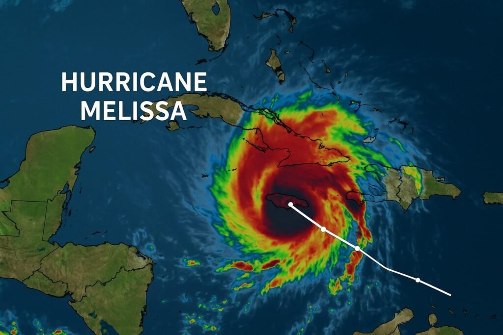
Melissa’s eyewall is tightening. Her wind speeds have topped 140 miles per hour and are still climbing. That makes her a solid Category 4 hurricane. Some models even suggest she could flirt with Category 5 just before landfall. But intensity isn’t the only concern. It’s the pace. Melissa is crawling at just a few miles per hour, which means Jamaica won’t just get hit once. It’s going to be battered over and over again by rainbands and dangerous gusts, especially overnight Monday into Tuesday.
The hurricane warning issued for Jamaica by the National Hurricane Center isn’t just routine. It’s one of the most serious alerts in years. Kingston is directly in the crosshairs. If the core tracks just slightly inland, the capital could experience one of the most intense storms in its modern history. Rainfall projections are staggering: 15 to 30 inches across much of the island, with some areas potentially exceeding 40 inches. That’s not rain you walk through with an umbrella. That’s landslide-inducing, river-swelling, car-floating kind of rain.
And it’s not just inland flooding that has officials worried. Coastal areas, especially on the southern side, face the added danger of storm surge. Imagine the sea not just rising slowly, but crashing into neighborhoods with large, battering waves on top of already high tides. The surge in some areas is expected to be several feet above normal, which is enough to inundate streets, trap vehicles, and erode parts of the coastline. When combined with the runoff from inland flooding, this creates what’s known as compound flooding. That’s when stormwater from land and sea combine into one major, chaotic mess.
Now consider the wind. Buildings that aren’t reinforced for this level of pressure may not hold. Roofs, power lines, trees, even mobile towers are vulnerable. Even if you’re not in the direct path of the eye, you could still experience wind gusts that down trees or rip loose items from yards. This is why officials are urging residents to stay indoors, avoid low-lying areas, and evacuate if local authorities have advised it.
Shelters have opened islandwide. From Montego Bay to Kingston, hundreds of facilities have been activated. But the response is mixed. Some residents are still hesitant to leave home, holding out until the last minute. Others are already packed and moving inland or to higher ground. Emergency services have made it clear: do not wait for conditions to deteriorate. Once roads are flooded or blocked by debris, it may be impossible to reach you. The U.S. Embassy in Kingston has echoed this message, urging all citizens to stay alert and act early.
As for transportation, both Norman Manley International and Sangster International airports are closed. Airlines have suspended all operations. That means no last-minute getaways. The island is in full hurricane mode. Curfews are being discussed in some parishes to discourage unnecessary movement and protect emergency crews. If you haven’t already secured your home and supplies, the window is closing fast.
What’s fueling Melissa’s intensity? It’s all about the water. The Caribbean Sea is unusually warm right now. Not just at the surface, but deep down. That heat acts like rocket fuel for hurricanes. When combined with minimal wind shear and a tight, well-defined eye, it sets the stage for rapid intensification. That’s exactly what happened over the weekend. In just 24 hours, Melissa jumped from a tropical storm to a major hurricane. Scientists and meteorologists say this is one of the fastest ramp-ups seen in recent years.
In historical context, Hurricane Melissa Jamaica could be as significant as Gilbert in 1988 or Beryl in 2024. But Melissa’s slow movement and potential to dump three feet of rain over steep terrain makes her a unique threat. Every part of the island, from the Blue Mountains to the coastal plains, is at risk for some kind of impact.
If you’re in Jamaica right now, you need to know your risk zone. Are you near a river, gully, or steep hill? Move to higher ground. Are you on the coast, especially on the southern side? Prepare for surge and wave action. Are you in a lightly built home? Seek sturdier shelter now. This storm isn’t going to play fair. It’s already slowed down and is expected to stall or move very gradually for another 24 to 36 hours. That means the rain, wind, and coastal flooding will stretch on for much longer than a typical hurricane pass.
Let’s be real. Most hurricane fatalities in the Caribbean aren’t from wind. They’re from water. Flash floods. Drownings. Landslides. Do not risk crossing flooded roads. Even a foot of fast-moving water can sweep away a car. Authorities are urging people not to wait for last-minute rescues. Emergency crews may be unable to respond in the middle of the storm. The safest thing you can do is act before the worst arrives.
If you lose power, and it’s likely many will, be ready with battery-powered radios, backup chargers, and flashlights. Water should be stored now. Fill bathtubs, buckets, and containers. If you’re in a rural area, expect power and water disruptions to last for days, maybe longer if infrastructure takes a hit.
One final word on forecast models. While Melissa’s path looks fairly direct, hurricanes wobble. A slight jog north or south could mean the difference between catastrophic winds in Kingston or more moderate gusts. But the rain is coming no matter what. The shape of the storm and its feeder bands will keep hammering Jamaica even if the center skirts offshore.
This is not the kind of storm to underestimate. The slow crawl, the intense rainfall, and the high-end wind speeds all combine into a high-impact system. Whether you’re inland or on the coast, urban or rural, Melissa doesn’t discriminate. The time to prepare is right now.