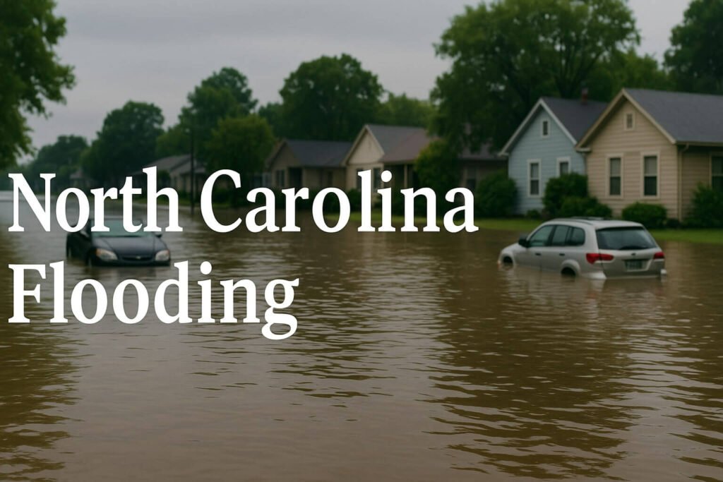
Tropical Storm Chantal may have fizzled fast, but the damage it left behind is anything but minor. Over the past two days, North Carolina flooding has dominated headlines and emergency bulletins alike, carving out one of the most intense inland flood events of the year. From the rain-choked neighborhoods of Chapel Hill to the dam-breached outskirts of Carthage, this week’s weather has been a sobering reminder of how vulnerable the state remains when slow-moving storms collide with saturated ground.
The Setup: Why Chantal Was So Dangerous
This wasn’t a hurricane. Chantal never hit the Carolinas with dramatic wind gusts or a clear-eyed center. What it did bring was slow movement, tropical moisture, and a stall over the Piedmont that became a perfect recipe for disaster. The storm’s remnants parked over central North Carolina late Sunday night. Locked in by a stubborn Bermuda ridge, it refused to budge. Warm Atlantic air kept streaming in, mixing with a soggy atmosphere that had already been holding more than its fair share of water vapor.
Rainfall totals in some counties were astonishing. Chapel Hill recorded over 170 millimeters in under 24 hours, while Hyco Lake near the Virginia border pushed close to 190 millimeters. Streets turned into rivers, and rivers turned into problems. The Eno River shattered its previous flood record by nearly a meter, and the Haw River at Bynum hit its highest level in fifty years.
Unlike a dramatic hurricane landfall, the North Carolina flooding this time was sneakier, slower and in many ways more dangerous. While residents were sleeping, water levels surged. Driveways vanished. Culverts collapsed. And by the time people woke up Monday morning, entire neighborhoods were underwater or cut off by debris-strewn roads.
Damage, Rescues and What Comes Next
Flooding damage hit a wide region, but a few places were hit especially hard. In Moore County, an earthen dam on the Little River gave way, releasing a torrent of water that tore through homes and fields near Carthage. In Orange County, dozens of businesses were left knee-deep in water after Eastgate Crossing turned into a brown lake overnight. Several first-floor apartments in Camelot Village filled up to window height in less than half an hour, prompting swift-water rescues that stretched into the next day.
Emergency crews were everywhere. Over 100 water rescues were recorded across the state, many involving stranded drivers and flooded homes. At least two fatalities have been confirmed, both linked to vehicles swept off rural roads. One victim was recovered from a submerged car in Chatham County, another was found after a washout near Carthage.
Shelters quickly opened in multiple counties, with nearly 500 residents seeking refuge from the rising water. Volunteers, Red Cross teams, and local officials rushed to supply food, water and emergency medical services. Public health teams have warned returning residents to watch for contaminated wells and mould outbreaks, both of which often follow events like this.
Power outages reached a peak of 37,000 customers, mostly concentrated around Orange and Chatham counties. Utility teams worked through the night, restoring service to the majority by Tuesday morning, although isolated pockets still lack electricity or internet.
Transport remains a tangle. At one point, 120 roads were closed, including a stretch of I-85 near Graham. North Carolina DOT had to reroute heavy truck traffic through secondary highways, adding hours to regional deliveries. Bridges and culverts, particularly in clay-heavy soil zones, have suffered visible damage, some likely needing full replacement.
Bigger Picture: Why This Matters
Tropical Storm Chantal’s aftermath lines up with a concerning trend. In recent years, North Carolina has seen a spike in severe rainfall events not tied to high-category hurricanes. The common theme is slower storms, loaded with moisture, getting stuck over the same region. Five “500-year” rainfall events have hit the state in the past decade alone, a number that used to be considered a once-in-a-lifetime possibility.
Climate researchers point to warmer ocean waters, changing jet stream patterns, and increased atmospheric moisture capacity as contributing factors. What used to be a day of heavy rain now turns into two days of relentless soaking, followed by infrastructure failure. For cities like Durham and Chapel Hill, that means overwhelmed storm drains, washed-out roads, and rivers that crest hours or even days after the rain ends.
This time, it was Chantal. Next time, it might be something smaller or something worse. What’s certain is that the North Carolina flooding threat is no longer just a coastal problem. Inland counties, especially across the Piedmont and Sandhills, now face seasonal flood risks that are growing with each passing year.
What to Watch Now
While skies have cleared over most of the state, the danger hasn’t fully passed. Rivers are still running high, with some gauges expected to peak midweek. Forecasters are also watching a new low forming near the Gulf Coast. This disturbance, if it holds together, could bring another round of heavy rain by Friday, especially to eastern North Carolina.
In the meantime, residents are being urged to:
- Avoid any flood-damaged roads, even if they appear dry
- Check well water for contamination if located in rural areas
- Disinfect and ventilate homes to prevent mould
- Document damage early for insurance purposes
- Monitor updates from local emergency management offices
It’s also a smart time to review your personal emergency kit. Flooding isn’t always predictable, and it doesn’t always come with sirens. Having essentials ready, from clean water to a flashlight and charger, can make a massive difference when hours count.
Final thoughts
The storm has passed, but its impact will linger. Communities will take time to rebuild, families will recover at their own pace, and infrastructure teams will be stretched as they assess long-term fixes. This event wasn’t just about rain, it was about resilience. The residents of North Carolina have seen floods before, but with changing climate patterns, events like these may become a more frequent part of life. Preparation, awareness, and strong local networks will be key to weathering the next challenge that comes with the skies.