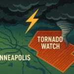
In a tense, storm-charged atmosphere sweeping across the Upper Midwest, tornado warnings are lighting up radars, phones, and weather radios in real time. It’s not just another summer thunderstorm night. This is one of those rare evenings where the sky flips the script, the clouds spin, and alerts buzz with a simple message: take cover now. The latest outbreak of tornado warnings stretches across multiple states, but right now, Minnesota is the epicenter. The National Weather Service has issued several warnings throughout the evening and early night, especially around the Minneapolis metro area.
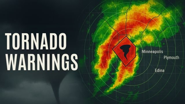
As of this hour, active tornado warnings are impacting cities like Minneapolis, Victoria, Chanhassen, Eden Prairie, Shakopee, Edina, Hopkins, Minnetonka, and Plymouth. These are not speculative alerts. Radar has shown clear rotation in several supercells moving through Carver, Hennepin, Wright, and Scott Counties, with storm spotters reporting funnel clouds and at least one confirmed tornado touchdown west of the metro. The tornado warnings are being updated minute by minute as storms track eastward at 30 to 40 miles per hour, powered by a potent mix of heat, humidity, and low-level wind shear.
Outside the core Minneapolis region, the warnings and watches ripple across surrounding areas. In St. Cloud, Maple Grove, Bloomington, and Brooklyn Park, residents are being advised to stay weather aware. The same goes for Rogers, Chaska, and Waconia, where earlier tonight some of the strongest rotations were observed. Each of these towns has felt the shadow of the warnings, with sirens blaring and people scrambling to find their safest interior rooms or basements.
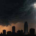
What’s especially unsettling tonight is that most of these tornado warnings are happening after dark. Nighttime tornadoes are more dangerous, less visible, and statistically more deadly. That’s why the National Weather Service’s multiple alerts, including Wireless Emergency Alerts, are so critical right now. Tornado warnings aren’t just an advisory, they’re the final notice before impact. When one is issued, you don’t hesitate, you don’t go outside to check the sky. You move — fast.
This evening’s severe setup was flagged earlier by NOAA’s Storm Prediction Center, which placed central and eastern Minnesota under a slight risk for severe weather. That label may sound tame, but slight risk days often turn severe when the ingredients mix just right. In this case, a juicy combination of 70°F dewpoints, strong instability, and favorable wind profiles gave rise to rotating supercells. By 8 p.m., the first storms were already producing golf-ball-sized hail near Mankato and New Ulm, with rotation tightening in cells approaching Waconia and St. Bonifacius.
Over the next few hours, new warnings extended into Excelsior, Wayzata, Golden Valley, and South Minneapolis. At least two separate cells have shown signs of tornado development, and the radar continues to paint a dangerous picture. The Twin Cities metro, home to over 3 million residents, is especially vulnerable on nights like this when urban density makes sheltering more complex. Mobile homes, outdoor events, and nighttime driving all increase the risk during tornado warnings, making quick communication and preparedness all the more vital.
Beyond Minnesota, severe thunderstorm watches and tornado watches blanket parts of northern Iowa, western Wisconsin, and even eastern South Dakota. While not every county has been upgraded to tornado warnings yet, the potential exists. This storm system is large, fast-moving, and energized. Cities like La Crosse, Rochester, Albert Lea, and Sioux Falls are all on notice. Even though some of these areas haven’t seen tornado warnings yet tonight, the atmospheric setup could change quickly.
So what can you do if your city pops up in the next tornado warning? First, don’t panic. Second, act fast. Your goal is to put as many walls between you and the outside as possible. Go to a basement if you have one. If not, an interior closet or bathroom works. Cover your head with a pillow or helmet. Keep shoes on and your phone charged. Nighttime tornado warnings leave little room for error, so every second counts.
There’s also a growing national trend toward better detection and faster alerts. The average U.S. tornado warning lead time is around 13 minutes, and improving radar technology is pushing that even further. But in the moment, it’s about you and your decision to trust the alert. These tornado warnings are not hypothetical. They are tied to real-world atmospheric signatures — hook echoes, debris balls, velocity couplets. Meteorologists don’t issue them lightly.
Looking ahead, the tornado threat may linger into the early morning hours as the storm line shifts east. Damaging wind gusts and hail are also possible in the wake of the tornadic cells. Even if the tornado warnings expire for your city, stay alert for new developments and secondary hazards like flash flooding or downed power lines.
This is a developing story. Cities like Minneapolis, Eden Prairie, St. Louis Park, Burnsville, Maplewood, and Inver Grove Heights may still be under watches or get pulled into new tornado warnings overnight. Keep your phone alerts on, monitor local weather radio stations, and follow trusted sources like the National Weather Service and CycloneRadar.
We’ll continue to monitor and update as more warnings are issued.