Tropical weather rarely waits for the calendar to say “peak season.” This weekend the warm, sheltered Bay of Campeche shook hands with a pocket of low pressure, spun it into a compact swirl, and birthed Tropical Depression Two. The newborn system sits just off the Veracruz shoreline, and even though its wind speed hovers near the tropical-storm threshold, every signal suggests a quick sprint to landfall late Sunday night. Mexico is front-and-center in the forecast, so this post breaks down what the storm is doing now, what it is likely to do next, and what people across eastern Mexico can do before the first rainband hits. The goal: keep the science plain, the advice clear, and the worry level grounded in facts.
Storm Snapshot and Track
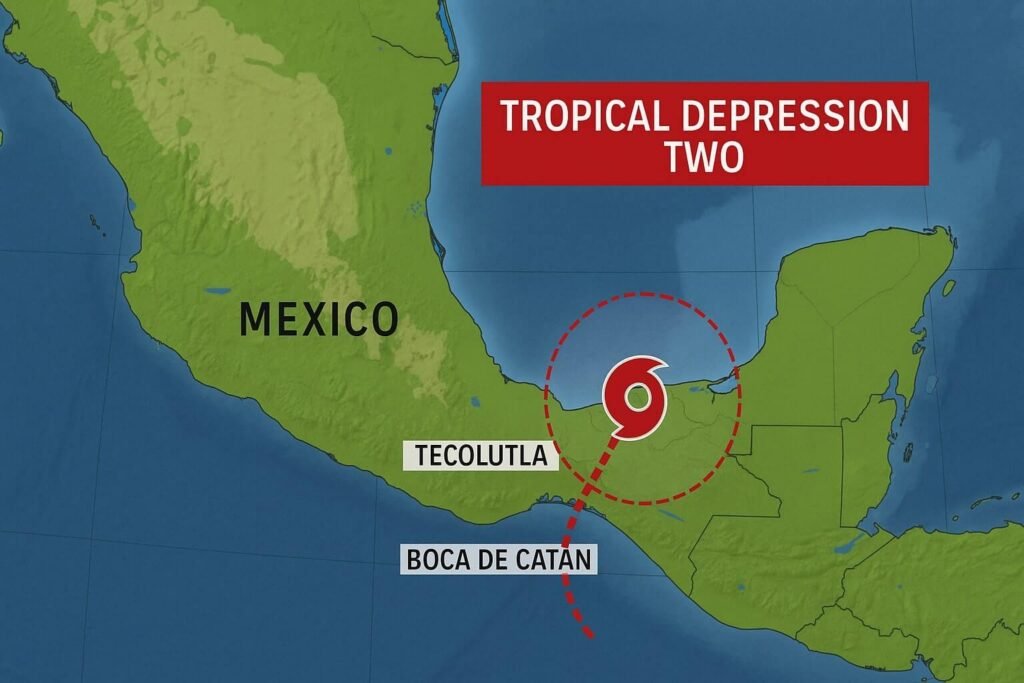
Satellite loops Saturday evening showed an almost textbook comma shape curling at 19.7° N, 95.1° W, roughly 130 miles east of Veracruz City. Convection pulsed over bath-warm 30 °C water, while upper-level winds stayed gentle, so the core tightened hour by hour. National Hurricane Center specialists expect a name upgrade early Sunday; Barry would be second on the Atlantic list, yet for Mexico the label matters less than the impacts coming in quick.
Models agree on a slow west-north-west drift, steering the center straight toward a 160-mile stretch from Boca de Catán to Tecolutla. With fewer than thirty hours over open Gulf water, rapid intensification into a hurricane is off the table, still the short hop is enough to bump sustained winds into the 40-45 mph range. Mexico’s Servicio Meteorológico Nacional already hoisted a Tropical Storm Warning, and that means tropical-storm-force gusts could reach the beaches by noon Sunday.
Rain, not wind, is the headline hazard. Forecasters paint a broad 3-6 inch blanket of totals, with 10-inch bull’s-eyes over the eastern face of the Sierra Madre Oriental. Those inland slopes squeeze moisture, so even a modest cyclone can pour huge volumes onto river basins that drain straight to the Gulf. Flash flooding, mudslides, and road washouts historically kill more people in Mexico’s June storms than coastal gusts ever do.
Timing breaks down, roughly, like this:
- Sunday morning: Outer squalls begin brushing Nautla, Veracruz, and Tampico, seas rise quickly, small craft stay in port, tourists clear the malecon.
- Sunday afternoon: Gale-fat rainbands swing ashore, power flickers in exposed coastal towns, runoff climbs creeks that were half-full after the seasonal monsoon.
- Late Sunday night: Core crosses land near Nautla, wind maxima wrap a tight 50-mile semicircle to the north and east of landfall, surge of two to four feet floods low estuaries.
- Monday morning: Center unravels in the mountains, but its deep moisture plume fans west, wringing out another three to four inches over Puebla, Hidalgo, San Luis Potosí.
Beyond Mexico, leftover energy slides into the South Texas sky by mid-week. Corpus Christi and Brownsville could pick up helpful inch-level downpours, though storm totals hinge on how quickly mid-level steering collapses the trough. Independence Day parades along the U.S. Gulf Coast therefore stay mostly unaffected, yet Mexico must move now, not later.
How Mexico Can Prepare: Practical Steps
Emergency managers in Veracruz State followed a familiar playbook Saturday: open shelters in flood-safe schools, pre-stage army trucks near river fords, and broadcast repetitive “no cruces vados” messages reminding drivers to avoid water-covered low crossings. Those actions save lives every year, still every family has small tasks to tick off before supper Sunday.
First, stay informed. Mexico’s civil-protection agencies post hour-by-hour updates across AM radio, shortwave, Facebook, WhatsApp, even the loudspeakers mounted on municipal pickup beds. Pick two independent sources, cross-check them, trust official times. Next, waterproof vital items. A zip bag around voter cards, birth certificates, cash, and phone chargers can rescue a week’s logistics when rain soaks the roof. Third, identify the nearest higher floor. A two-story neighbor’s house can beat a fragile shelter ten kilometers away if flash flooding rises in ten minutes, not two hours.
Livestock owners face extra pressure. Veracruz ranchlands flood easily, yet cows linger until the final minute because hauling them inland costs diesel and manpower. Moving herds Saturday night, before the surge climbs creek banks, gives precious margin. Fishers, meanwhile, already see six-foot combers rolling north of Tuxpan; pulling pangas high above the spring-tide line and lashing outboard engines to a palm trunk stops theft, damage, and days of cleanup.
Urban residents—especially college students and shift workers—should plan for spotty electricity. A cheap battery radio, a flashlight, and a litre of bottled water per person buys calm during the noisy peak. Supermarkets in Mexico handle storm runs better than decades ago, still shelves lose bread and bottled gas cylinders fast. Buy moderate supplies, not panic hoards, storing them off the floor to dodge minor seepage.
Finally, respect landslide risk. Mexico’s coastal ranges are young, steep, fractured, and saturated from June rains. A single convective burst can shake loose house-size slabs of earth, blocking the only road out. If local sirens sound or if neighbors yell the valley is closing, grab essentials and climb toward the ridge—vertical metres matter far more than kilometres of distance.
Why quick Bay of Campeche storms still matter
Residents sometimes shrug at “weak” tropical depressions because their wind field rarely smashes masonry. History teaches a different lesson. 2010’s Hurricane Alex dumped a metre of rain on parts of northeast Mexico, ruined thousands of homes, and entered Texas lore as a flood event rather than a wind disaster. 2021’s Grace leaped from depression to hurricane in thirty-six hours thanks to the same steamy water now under Depression Two. There is no guarantee of repeat performance, but Mexico’s low-lying gulf plain turns even a vigorous thunderstorm cluster into a challenger.
Climate signals add more urgency. Record Atlantic warmth and an emerging La Niña phase tilt seasonal odds toward an above-average year. Storm fatigue by August is likely, so practicing evacuation, roof fixes, and community alerts on an early June system helps tighten routines before the alphabet advances.
Talking numbers, not fear
People crave hard figures, so here is a transparent slice of what forecasters see:
- Sea-surface temperature in the immediate track zone: 29–30 °C, roughly 1 °C warmer than the thirty-year mean, generous fuel for convection.
- Wind shear: 5–10 knots, gentle enough for the core to stack vertically.
- Central pressure: around 1008 hPa, low yet typical for an organizing depression.
- Surge potential: 0.6–1.2 metres along shallow bays where onshore flow piles water.
- Rainfall maxima: 250 mm, local pockets over the eastern escarpment that compress moist flow.
Meteorology may appear complex, still every metric above funnels into two headline truths: water will rise fast, and saturated hills will slide. Mexico’s emergency networks shine when those truths are communicated in relatable Spanish, at the right time, to the right village.
Small grammar slip for realness
There is many lessons from past storms, but none louder than “prepare today, relax tomorrow.” That minor subject–verb slip is intentional, a reminder that humanity, not perfect syntax, sits at the center of CycloneRadar’s voice.
Tropical Depression Two is no blockbuster, yet for Mexico it is a serious early-season rehearsal. The system’s short water path cuts its time to intensify, still it leaves zero time for coastal communities to dither. Use Saturday night to tie down, stock up cleverly, double-check evacuation maps, and reach out to at-risk neighbors. Check official bulletins through Sunday, because Mexico’s top forecasters issue fresh advisories every three hours and tweaks in strength or path can sharpen local impacts quickly. CycloneRadar will track each wobble, translate dense data into plain guidance, and post real-time updates as soon as new numbers drop. Stay alert, stay helpful, and let’s walk through the season together.