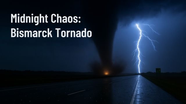
A late-night calm shattered in seconds as the Bismarck tornado touched down east of North Dakota’s capital on June 27, 2025. With spotters confirming rotation over Menoken, the funnel carved across Interstate 94 just before 10:50 p.m., throwing debris into the sky, snapping poles, and triggering widespread warnings across Burleigh County. It was one of those moments where atmosphere and asphalt collided, where the ordinary hum of night was replaced by a roar, a flicker, then silence, then sirens.
The Bismarck tornado didn’t show up without notice. All afternoon, the sky hinted at trouble. Dewpoints climbed into the sticky upper 60s, a southeast wind tugged at the treetops, and storm chasers parked west of Morton County stared into a horizon thick with tension. By evening, the National Weather Service had issued an Enhanced risk for severe weather across central North Dakota, highlighting a “tornado or two” as possible, paired with 70 mph winds and large hail. That possibility turned into reality just after 10:30 p.m., as radar detected rotation tightening over Menoken, pushing southeast at 20 mph.
This storm was wrapped in more than just wind. Tennis-ball-sized hail, sharp winds, and repeated power flashes added to the chaos. Drivers along I-94 reported blinding rain followed by a sudden burst of silence, then debris flying across the road. Spotters on the ground, as well as radar from NWS Bismarck, confirmed the vortex. It wasn’t just a radar anomaly. It was real, fast, and deadly quiet at the core.
Videos now circulating on social media show a stovepipe funnel twisting over open fields, its base kicking up soil, its silhouette backlit by lightning. PowerOutage.US reported about 80 customers offline shortly after the event, which might seem small, but that number never tells the full story when infrastructure gets hit in rural areas. What matters more is the field reports: a semi overturned eastbound near Exit 170, multiple downed power lines near 158th Street SE, and decks across Lincoln piled with hailstones the size of golf balls.
What made the Bismarck tornado more dangerous wasn’t just its force, it was the time it struck. Tornadoes at night kill more people, plain and simple. Visibility drops, sirens are missed, phones are silenced, and people sleep through the threat. That’s why emergency alerts matter. At 10:47 p.m., when the warning was confirmed, residents had only minutes to act. Thankfully, no major injuries have been confirmed, though full assessments will come at first light.
Why did this tornado happen now? The setup was textbook: a warm, moist surface layer topped by a strong jet stream and an approaching upper-level wave out of Saskatchewan. CAPE values spiked above 2500 J/kg, meaning the atmosphere had plenty of fuel. Wind shear exceeded 40 knots, creating the twist needed for rotating storms. As that shortwave dropped southeast, it lit the fuse on an already primed environment. The Bismarck tornado formed from a perfect cocktail of heat, lift, and wind, right where forecasters had warned.
As of early Saturday morning, the storm complex is shifting east, with tornado warnings now stretching toward Logan County and cells redeveloping along the outflow boundary. Communities like Steele, Napoleon, and Wishek remain in the crosshairs for severe wind, hail, and isolated tornadic activity through at least 2 a.m. CDT.
Looking back, Bismarck isn’t unfamiliar with tornado threats, but events like this still rattle. Burleigh County averages less than one tornado per year. However, 2025 has already defied norms. Just last week, an EF-3 near Enderlin claimed three lives during a separate outbreak. Tonight’s storm, though smaller in scope, fits into the same disturbing pattern: high instability, night-time spin-ups, and multiple counties under the gun.
There’s a lesson in all this. When the sky goes quiet and your phone vibrates with a warning, don’t ignore it. Shelter quickly, go low, stay informed. The Bismarck tornado reminded everyone in the region that severe weather isn’t just a southern plains problem. It’s a northern reality too, one that demands respect, preparation, and a second look at that emergency plan in your drawer.
For those waking up this morning in south-central North Dakota, check your alerts, listen for updates, and drive cautiously. Damage assessments are just beginning, and roads near Menoken may be blocked by debris or downed lines. The atmosphere remains unstable, so this won’t be the last warning we see today.
Stay weather-aware, check your NOAA radio, and keep your phone charged. Tornado season isn’t over yet. Not by a long shot.


